Tuesday, October 1, 2013

Monthly Weather Review: September 2013 Much Quieter!


After the wettest summer (June-July-August) on record, September 2013 was much much quieter by comparison.  Temperatures through the month averaged out to be very close to the 30 year normals and we ended up being only a little under an inch below normal on rain for the month.  In fact, only 8 of the 30 days in September had rainfall of 0.1 inches or better.

October is off to a warm and dry start, but that will change next week behind the next cold front.  Overall though, the Climate Prediction Center (CPC) predicts above average temperatures for October and near normal precipitation.

October 2013 Temperature Outlook (Courtesy: CPC)


 October 2013 Precipitation Outlook (Courtesy: CPC)

In case you're wondering, the CPC predicted near normal rainfall for last month and above normal temperatures...so they were 1 for 2 locally on their predictions for September.  Enjoy what should turn out to be some beautiful fall colors the next few weeks!


Monday, September 2, 2013

Monthly Weather Review: August 2013 - Wet, Wet, WET!


If July was "wild" as I stated a month ago, I'm honestly not sure what to say about August.  The rainfall for the month is definitely the standout (and not in a good way).  We saw 3.02 inches of our monthly total on August 28th alone!  We'll have to wait to see if it goes down as the wettest August on record in Clarksburg, but if not, it will certainly rank high on the list.  Both our high and low temperatures averaged out to be slightly below the 30 year normals, but not by much.


We saw an impressive 20 inches of rain this summer (June-August), making it the wettest summer on record in Clarksburg.  Thinking back on the summer that was, I don't think that comes as much as a surprise.


After today, temperatures are expected to be slightly below average for the next week, but overall, temperatures over the next month according to the Climate Prediction Center (CPC) are expected to be near normal with precipitation over the next month staying above normal.

September 2013 Precipitation Outlook (Courtesy: CPC)


 September 2013 Temperature Outlook (Courtesy: CPC)

I mentioned it last month, but all of this wet weather should mean a nice show of fall colors in a few weeks!

Thursday, August 1, 2013

Monthly Weather Review: July 2013 - Wet & Wild


I don't know if we can call July "wild" (maybe with all the rain we saw), but it certainly was a lot different than last July.  We saw only one week of big heat and humidity in the middle of the month followed by a string of unusually cool and unsettled days toward the end of the month.  Otherwise, temperatures through the month were right around where they should be this time of year...in the 80s.  Our average high through the 31 days in July 2013 was only a little over 2 degrees below the 30 year normal for July in Clarksburg.  Lows through the month averaged out to be a degree and a half above the norm for July.  In both cases, this is nothing to really write home about.  Rainfall for the second month though was significantly above the 30 year normal with over 6 inches of rain again in Clarksburg in July.

So, how do things look as we start August?  Well, we're starting on a cool note today, and it looks like that trend will continue for the first 2 weeks of the month.

8-14 Day Temperature Outlook (Courtesy: CPC)

It looks like the pattern we've seen for much of the summer (trough in the East, ridge in the West) is staying put to start off the month.  So, we can expect more of the same: unsettled weather at times with multiple storm systems and disturbances leading to wetter than average weather and a flow out of the north and west keeping us cooler than average.

8-14 Precipitation Outlook (Courtesy: CPC)

So, will this pattern ever break and will we see more summer-like weather before summer comes to an end?  The outlook from the CPC isn't looking good on that front.  The heat is expected to stay out west for the next several months.  The good news though is that if the wet weather continues, we should be in for a good show when the leaves change color come fall!

Wednesday, July 24, 2013

Get Local Weather Alerts 24/7 On My Social Media Sites & Sent Directly To Your Phone!

If you follow me on Facebook, Twitter, or Google+ (or maybe on all 3), you've noticed I've been doing a LOT of testing lately to figure out the best way to have local weather alerts auto-post to my social media.  The good news is, I finally have things set up.  It's not ideal (you have to click a link or view summary in Twitter to see specifics), but as I've found this is the only way to post quickly and to all 3 social media sites.


Basically, I have local alerts published to a Tumblr blog for the 20 counties inside the orange line in the picture above and those posts are forwarded to Facebook, Twitter, and Google+.  When the alerts are passed along to Facebook, Twitter, and Google+, they will look something like this:

Click to Enlarge

More detailed information is available by clicking the link in the post.  This will direct you to the blog post for the alert in Tumblr, a blogging site.

Click to Enlarge

If you didn't see the summary for the weather alert (if you're on Facebook or Google+), you will now see a summary giving the counties in the alert and when the alert expires.  For more information, you can click on the "iNWS Alert" title near the top of the post to get more detailed information about the alert (similar to what you would see in a scroll at the bottom of your screen on WDTV or WVFX).

Click to Enlarge

The more detailed look shows a map of the area affected and gives more specifics below it.

Overall, it's pretty simple...you just have to remember that there are 2 links to click...1 in the social media post and 1 on the Tumblr post after you click the first link (if you want more detailed info).

..................................................................................................................................

The cool thing about it being set up this way too is that you can easily receive these weather alerts directly on your smartphone or tablet via an RSS Reader with Push Notifications (don't let that scare you off, I have more instructions on setting it all up below).  iPhone users now receive weather alerts on their phones automatically, but they usually don't have very detailed info so the advantage to what I'm about to show you is that you can get the weather alert immediately after it is issued AND have a link to get more detailed information on it.

This works great on Android devices (I have personally tested it) and should work fine on iPhones, iPads, and iPods.  Theoretically, there is likely a way to do this on Blackberry and Windows Phone too, although I don't have enough experience with either to give a detailed tutorial (but maybe someone can help me out with that!).


Android:

1. Download and install the RSS reader "RSS Junkie" from the Google Play store: https://play.google.com/store/apps/details?id=com.bitpowder.rssjunkie&hl=en
2. Once installed, open the program
3. Click the menu button (3 vertical dots) on the top right of the screen
4. Choose "Add Feed..."
5. Select "Manually add a feed address"
6. Type in the following: http://piercelegeion.tumblr.com/rss
7. Click "Add".
- This has added the weather alerts feed to the program.  Now, you'll want to make sure the program is set up to receive push notifications.

8. Click the menu button (3 vertical dots) on the top right of the screen
9. Select "More..." then "Preferences..."
10. Under "Notification Preferences", click "Enable Notifications", then select which types of notifications you'd like to receive (Vibrate, LED, and/or Notification sound).
- You're now set up to automatically be notified any time there is a weather alert in the area and will be able to click on the notification to see more information!


iOS (iPhone, iPad, iPod):

1. Download and install the RSS reader "Blogkeen" from the app store: https://itunes.apple.com/us/app/blogkeen-rss-reader-for-blogs/id437002915?mt=8
2. Once installed, open the app.
3. Click the "More" tab at the bottom right of the screen.
4. In the search field, enter the following: http://piercelegeion.tumblr.com/rss
5. Select "Weather Alerts" and follow prompts to add to reader.
6. Go into the settings for the app and make sure push notifications are enabled or selected (sorry, I don't have an iOS device to test this out totally)


If you have any questions or if there is anything I missed, please let me know.  This is a service for you guys so I will do my best to work out any kinks that may still be left.  Also, if you have better instructions for getting the RSS feed going on iOS, Blackberry, or Windows Phone, please feel free to share with me.  Thanks!

Monday, July 1, 2013

Monthly Weather Review: June 2013 - Wet & Steamy


If you thought that June 2013 seemed like a wet month, you'd be right.  In Clarksburg, rainfall was over 2 inches above the 30-year normal for June.  A good chunk of north central West Virginia had been on the verge of drought conditions if we didn't see some rain and this should certainly help out with that.

Temperatures in June 2013 were pretty close to the 30-year normals for both highs and lows, with our average high for the month being around 3 degrees below the 30-year normal for June and our average low for the month about 3 degrees above the 30-year normal.

More wet weather and near normal temperatures are on the way for the start of July.  There are indications in the long term (toward the middle of the month) that the big ridge of high pressure which is out over the western U.S. could shift eastward a little bit.  There is still some uncertainty as to how far east it could build, but with a trough in the East to start the month and a large high pressure system over the middle of the country by the middle of the month, things look to stay wet here across north central WV.

Wednesday, June 12, 2013

Severe Weather Today & Tomorrow: What Can You Expect?

We've been talking the past few days about the likelihood for severe weather the next few days, and now that it is just about here, I've got a more clear picture of what to expect.  Thunderstorms will get going this afternoon as a warm front just to our south moves north into NCWV.  A strong disturbance will be riding in along that front late this afternoon which will help provide some additional lift and wind shear to give us an elevated risk for severe weather this afternoon through the first half of tonight.


Storms will start south and west near Glenville, Harrisville, and Sutton first around 3pm and work north and east from there.  These storms don't look to clear the area entirely until about midnight, when they will be across southern PA, the eastern panhandle of WV, and western and central MD.  The storms today will be capable of producing heavy rain (which could cause flash flooding in spots), damaging wind gusts of 60+ mph at times, large hail the size of a quarter or bigger, and an outside shot at a tornado or two.  Winds may be strong enough to down trees and power lines in some spots, although I do expect widespread power outages at this time.  The threat level for each is shown below:


It's important to note that the graphic above shows the percent chance of each hazard within 25 miles of a point (your house for example).  Considering that, a moderate threat is pretty significant.  The Storm Prediction Center (SPC) has actually cut back on the threat level for damaging winds and large hail to areas close to the Ohio River and west only early this morning, but that could once again change so I'll keep what I have here for now.


We quiet down a little bit after midnight tonight with a few scattered showers and a thunderstorm or two which won't be strong or severe.  As we head toward tomorrow morning though, round 2 of thunderstorms will move through the area with a cold front.  These storms are not expected to be as strong as what we'll likely see today, but there could be wind gusts of 40-50 mph and heavy rain as round 2 starts near the Ohio River around 6am and moves east from there, clearing the mountains by about 2pm.

In addition to the threat for gusty winds and hail, heavy rain may lead to flash flooding in some areas.  I'm expecting 1-2 inches of total rainfall today through late tomorrow, with much of that falling in a short amount of time with the 2 rounds of thunderstorms.  This is something else we'll be watching very closely through late tomorrow.  We'll keep you updated through the day on Channel 5 and online at WDTV.com.

For more info on preparing for severe weather, including getting an emergency kit together and how to find the safest place to take shelter from severe weather in your home, check out the links below.

Preparing For Severe Weather Part 1: One Item No Home Should Be Without
http://www.wdtv.com/wdtv.cfm?func=view&section=5-News&item=Preparing-For-Severe-Weather-One-Item-No-Home-Should-Be-Without9673

Preparing For Severe Weather Part 2: Finding Your Safe Place
http://www.wdtv.com/wdtv.cfm?func=view&section=5-News&item=Preparing-For-Severe-Weather-Finding-Your-Safe-Place9813

Thursday, June 6, 2013

Tropical Storm Andrea: What To Expect Here

Click to enlarge

Tropical Storm Andrea will make landfall in Florida late today, then continue north and east up the East Coast.  Andrea will pass well east of NCWV during the day tomorrow, keeping most of the effects from the storm east of the Appalachians.  We will see some rain today as a front slowly moves through and then again tomorrow as we'll be on the fringe of the rains from Andrea and that front will still be close enough to touch off some showers and storms through tomorrow.  Conditions will slowly improve as the storm pulls away Saturday, with a few showers in the morning transitioning to a drier afternoon with skies becoming partly cloudy.  In the meantime, here is what to expect today and tomorrow thanks to the front and what will be left of Andrea as it moves up the coast.


- 1 or 2 stronger thunderstorms are possible later this afternoon as the front moves in, but this threat is low.
     - Winds with a few of these storms could briefly gust to 40 or 50 mph.

The other threat we'll be watching the next few days is flooding.

- Overall, the threat for flooding is low.
     - It has been dry recently and the ground in most cases should be able to hand the 1-2 inches of total rainfall expected through late Friday.
     - Any areas that see a lot of rain in a short period of time will need to be watched closely for flooding concerns.

Total expected rainfall through late Friday (click to enlarge)

Monday, June 3, 2013

Monthly Weather Review: May 2013 - Warm & Dry


After a very dry April, we fell further behind in the rain bucket during the month of May 2013.  Normally, a one inch rainfall deficit during a month wouldn't be a big deal, but after falling behind by 2 inches in April, it is significant as the deficit continues to grow.

Much of the area is still in the "abnormally dry" category in the latest drought monitor, with some areas of moderate drought now in parts of Wetzel, Marion, and Mon counties.


Click to enlarge

Right now, it looks like a good soaking rain will be hard to come by over the next week.  There will be a system coming up from the tropics through the Gulf of Mexico this week, but it looks like the heavy rains with that will pass by to our east and up the East Coast.

Temperatures during May 2013 were slightly above "normal" (30-year average).  Our average high for the month was 74.3 degrees, almost a degree above normal, and our average low for the month was 50.8 degrees, over 2.5 degrees above normal.

The official long term forecast has the Mountain State seeing near normal temperatures and precipitation for the month of June.

Friday, May 3, 2013

Monthly Weather Review: April 2013 / Dry Dry Dry!


April 2013 will be noted as one of the drier April's on record.  It did not end up being one of the top 10 driest April's in Clarksburg, but a 2 inch rain shortfall is definitely noticeable.  Temperatures ended up being above the 30-year normal for both highs and lows by several degrees, and after what seemed like an endless winter, we saw no snow in Clarksburg in April (although the mountains did see some light snow through the month).

A dry April has led to much of the northern part of the state being placed in an "abnormally dry" category on this week's drought monitor.


Click to enlarge

This category is not officially considered a drought category but it can be a sign that with continued dry weather, drought conditions may develop.  We look to stay dry and sunny right through the weekend.  A storm which has been plaguing the middle of the country with rain and snow (yes snow in May) will head our way early next week.  Right now, it looks like it will pass to our south, taking the really good soaking rains with it.  All week the models has been all over the place with this storm, but more and more of them are starting to come on board with a track across the southeastern U.S.  Unfortunately for those hoping for some beneficial rains, it looks like we may have to wait a while for a good soaker.  The latest forecast for rainfall over the next week has some impressive amounts falling, just not here unfortunately.

Forecasted rainfall through Friday, May 10th

However, a more northward shift to the current forecast track of this storm would mean more rain for us here in the Mountain State.  The track is certainly not set in stone yet, but the fact that more and more of the models are jumping on board with this solution may mean we'll have to wait a little longer for a good soaking rain.


Saturday, April 13, 2013

April 13th Northern Lights Viewing in WV?

A view of the northern lights in Elmira, N.Y., from 2011. Photo by David St. Louis

Thanks to a moderate solar flare (and actually the strongest solar flare so far this year) which erupted from the sun very early in the morning on April 11th, we have a good shot at seeing the aurora borealis, also known as the Northern Lights, here in north-central West Virginia (and a good chunk of the northern part of the U.S. for that matter).  Much of the radiation from this solar flare is expected to pass through the Earth's atmosphere tonight.  The interaction of these solar particles with the Earth's magnetic field is what causes the Northern Lights.  Solar flares create auroras when radiation from the sun reaches Earth and interacts with charged protons in the atmosphere. The effects are greater at the magnetic poles and weaken as you move south from the Arctic or north of the Antarctic.

Astronomers use a simple index to represent the level of geomagnetic activity for a 3-hour time period known as the K-index, or Kp.  The map below shows the Kp index needed for certain parts of the country to be able to see the Northern Lights.


Based on this map, the Kp index needs to be at around an 8 for us to see the Northern Lights here in north-central West Virginia.  Kp for tonight is projected to be in the 6-8 range, putting us on the very southern fringe of a possible viewing.  Since it looks like we will be on the southern fringe, the lights may be very low on the northern horizon, so it will be very important to follow these tips if you want to see them:

- Get out and away from city lights and street lights.  These will hamper viewing.  You'll want a dark and clear sky for best viewing.
- Get on a hilltop so you have a complete view of the sky and don't have your view of the horizon blocked by trees or hills.
- The lights are projected to start around 8pm EDT tonight (right after sunset), but the best viewing will be around midnight tonight.
- Folks who have photographed the lights say that cell phone cameras will not capture them.  You'll need a professional grade camera shooting in night mode for best results.  I am no photographer but maybe someone with some more expertise can chime in on this.

The GREAT news weather-wise is that skies should be clear to mostly clear by late afternoon and through the overnight, making for great viewing conditions.


It will be cold though with lows falling into the low to mid-30s tonight so bundle up if you plan on trying to head out and see them.

Another bit of good news for viewing tonight, the moon is just past the new moon stage and only about 10% full, which will help in decreasing light in the sky that could block viewing tonight:


I'd love to see any photos or videos you may grab tonight too (and I'm going to see what I can get).  You can email them to me at plegeion@wdtv.com, or share them with me on social media.  Links to my Facebook, Twitter, and Google+ pages can be found here (at the bottom of the page): http://about.me/pierce.legeion

Good luck!  I hope we all get a nice treat in seeing the Northern Lights tonight!


Updated Kp forecast available here: http://www.softservenews.com/Aurora.htm
Tips on viewing the aurora and other info here: http://www.swpc.noaa.gov/Aurora/

Monday, April 1, 2013

Monthly Weather Review: March 2013


March 2013 will definitely be remembered for its prolonged but not highly unusual cold snaps.  Temperatures through the month, particularly high temperatures, certainly reflect this.  Our average high temp through the month of March was over 6 degrees below the monthly normal, while our average low temperature through the month was pretty close to the 30 year normal.  Despite all the cold, we were drier than normal by a little over an inch.  Snowfall was below normal as well (at least in Clarksburg) by a little more than three and a half inches.  

This is a HUGE contrast to what we saw both temperature and precipitation-wise across the state just a year ago in March 2012, when we saw the warmest March on record and one of the wetter Marches on record:


Saturday, March 23, 2013

Snowfall Forecast: Sunday Night - Tuesday

Disclaimer: This is my own personal forecast and does not necessarily reflect the forecast at WDTV Channel 5.  Please go to WDTV.com for the First Alert Stormcenter Forecast.

Here are my thoughts and what I'm thinking for total snowfall accumulations across the area from this next winter storm:


Friday, March 22, 2013

March 18-22: Flood Safety Awareness Week

March 18th - 22nd is Flood Safety Awareness Week.  Here's a nice recap from the National Weather Service in Charleston, WV:


Spring is here, so where's the spring-like weather?

Spring began at 7:02 am on Wednesday, but we haven't seen any spring-like weather since then, and it looks like we have a VERY long road before we do see it.  Below is the 7 day forecast for next week and the Climate Prediction Center's (CPC) temperature and precipitation outlook through April 4th.


You'll notice that we still have plenty more in the way of winter weather to go the next week or two.  For what it's worth, precipitation will be a little below normal, so hopefully that will mean not much more in the way of snow.  The good news is that beyond early April, there are signs that some more spring-like weather will be rushing in.  Longer range forecasts show the jet stream relaxing and heading north into Canada, which would finally allow the eastern half of the country to warm up more permanently.  The question still is exactly when that will happen.  A few days ago, it looked like next week would be the last week of cold before a more long term warm-up.  As of today, it is looking more like a week and a half to two weeks of cold weather before things warm up around April 5th and beyond.  Once we do warm things up though, indications are that we'll stay warm for quite some time with above normal temperatures expected through the rest of spring and into summer according to the CPC.


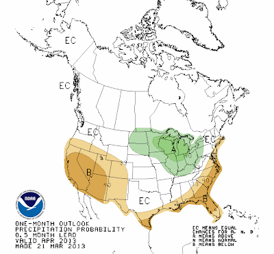
April temperature and precipitation outlooks from the CPC


April, May, and June precipitation outlooks from the CPC

Precipitation will stay near to slightly above normal from April - June according to CPC forecasts.  Just wanted to throw a little ray of hope out there that spring will (eventually) be on it's way!