Monday, July 15, 2013
Monday, July 1, 2013
Monthly Weather Review: June 2013 - Wet & Steamy

If you thought that June 2013 seemed like a wet month, you'd be right. In Clarksburg, rainfall was over 2 inches above the 30-year normal for June. A good chunk of north central West Virginia had been on the verge of drought conditions if we didn't see some rain and this should certainly help out with that.
Temperatures in June 2013 were pretty close to the 30-year normals for both highs and lows, with our average high for the month being around 3 degrees below the 30-year normal for June and our average low for the month about 3 degrees above the 30-year normal.
More wet weather and near normal temperatures are on the way for the start of July. There are indications in the long term (toward the middle of the month) that the big ridge of high pressure which is out over the western U.S. could shift eastward a little bit. There is still some uncertainty as to how far east it could build, but with a trough in the East to start the month and a large high pressure system over the middle of the country by the middle of the month, things look to stay wet here across north central WV.
Wednesday, June 12, 2013
Severe Weather Today & Tomorrow: What Can You Expect?
We've been talking the past few days about the likelihood for severe weather the next few days, and now that it is just about here, I've got a more clear picture of what to expect. Thunderstorms will get going this afternoon as a warm front just to our south moves north into NCWV. A strong disturbance will be riding in along that front late this afternoon which will help provide some additional lift and wind shear to give us an elevated risk for severe weather this afternoon through the first half of tonight.


For more info on preparing for severe weather, including getting an emergency kit together and how to find the safest place to take shelter from severe weather in your home, check out the links below.
Preparing For Severe Weather Part 1: One Item No Home Should Be Without
http://www.wdtv.com/wdtv.cfm?func=view§ion=5-News&item=Preparing-For-Severe-Weather-One-Item-No-Home-Should-Be-Without9673
Preparing For Severe Weather Part 2: Finding Your Safe Place
http://www.wdtv.com/wdtv.cfm?func=view§ion=5-News&item=Preparing-For-Severe-Weather-Finding-Your-Safe-Place9813

Storms will start south and west near Glenville, Harrisville, and Sutton first around 3pm and work north and east from there. These storms don't look to clear the area entirely until about midnight, when they will be across southern PA, the eastern panhandle of WV, and western and central MD. The storms today will be capable of producing heavy rain (which could cause flash flooding in spots), damaging wind gusts of 60+ mph at times, large hail the size of a quarter or bigger, and an outside shot at a tornado or two. Winds may be strong enough to down trees and power lines in some spots, although I do expect widespread power outages at this time. The threat level for each is shown below:

It's important to note that the graphic above shows the percent chance of each hazard within 25 miles of a point (your house for example). Considering that, a moderate threat is pretty significant. The Storm Prediction Center (SPC) has actually cut back on the threat level for damaging winds and large hail to areas close to the Ohio River and west only early this morning, but that could once again change so I'll keep what I have here for now.

We quiet down a little bit after midnight tonight with a few scattered showers and a thunderstorm or two which won't be strong or severe. As we head toward tomorrow morning though, round 2 of thunderstorms will move through the area with a cold front. These storms are not expected to be as strong as what we'll likely see today, but there could be wind gusts of 40-50 mph and heavy rain as round 2 starts near the Ohio River around 6am and moves east from there, clearing the mountains by about 2pm.
In addition to the threat for gusty winds and hail, heavy rain may lead to flash flooding in some areas. I'm expecting 1-2 inches of total rainfall today through late tomorrow, with much of that falling in a short amount of time with the 2 rounds of thunderstorms. This is something else we'll be watching very closely through late tomorrow. We'll keep you updated through the day on Channel 5 and online at WDTV.com.
For more info on preparing for severe weather, including getting an emergency kit together and how to find the safest place to take shelter from severe weather in your home, check out the links below.
Preparing For Severe Weather Part 1: One Item No Home Should Be Without
http://www.wdtv.com/wdtv.cfm?func=view§ion=5-News&item=Preparing-For-Severe-Weather-One-Item-No-Home-Should-Be-Without9673
Preparing For Severe Weather Part 2: Finding Your Safe Place
http://www.wdtv.com/wdtv.cfm?func=view§ion=5-News&item=Preparing-For-Severe-Weather-Finding-Your-Safe-Place9813
Friday, June 7, 2013
Thursday, June 6, 2013
Tropical Storm Andrea: What To Expect Here

Click to enlarge
Tropical Storm Andrea will make landfall in Florida late today, then continue north and east up the East Coast. Andrea will pass well east of NCWV during the day tomorrow, keeping most of the effects from the storm east of the Appalachians. We will see some rain today as a front slowly moves through and then again tomorrow as we'll be on the fringe of the rains from Andrea and that front will still be close enough to touch off some showers and storms through tomorrow. Conditions will slowly improve as the storm pulls away Saturday, with a few showers in the morning transitioning to a drier afternoon with skies becoming partly cloudy. In the meantime, here is what to expect today and tomorrow thanks to the front and what will be left of Andrea as it moves up the coast.

- 1 or 2 stronger thunderstorms are possible later this afternoon as the front moves in, but this threat is low.
- Winds with a few of these storms could briefly gust to 40 or 50 mph.
The other threat we'll be watching the next few days is flooding.
- Overall, the threat for flooding is low.
- It has been dry recently and the ground in most cases should be able to hand the 1-2 inches of total rainfall expected through late Friday.
- Any areas that see a lot of rain in a short period of time will need to be watched closely for flooding concerns.

Total expected rainfall through late Friday (click to enlarge)
Monday, June 3, 2013
Monthly Weather Review: May 2013 - Warm & Dry

After a very dry April, we fell further behind in the rain bucket during the month of May 2013. Normally, a one inch rainfall deficit during a month wouldn't be a big deal, but after falling behind by 2 inches in April, it is significant as the deficit continues to grow.
Much of the area is still in the "abnormally dry" category in the latest drought monitor, with some areas of moderate drought now in parts of Wetzel, Marion, and Mon counties.


Click to enlarge
Right now, it looks like a good soaking rain will be hard to come by over the next week. There will be a system coming up from the tropics through the Gulf of Mexico this week, but it looks like the heavy rains with that will pass by to our east and up the East Coast.
Temperatures during May 2013 were slightly above "normal" (30-year average). Our average high for the month was 74.3 degrees, almost a degree above normal, and our average low for the month was 50.8 degrees, over 2.5 degrees above normal.
The official long term forecast has the Mountain State seeing near normal temperatures and precipitation for the month of June.
Friday, May 3, 2013
Monthly Weather Review: April 2013 / Dry Dry Dry!

April 2013 will be noted as one of the drier April's on record. It did not end up being one of the top 10 driest April's in Clarksburg, but a 2 inch rain shortfall is definitely noticeable. Temperatures ended up being above the 30-year normal for both highs and lows by several degrees, and after what seemed like an endless winter, we saw no snow in Clarksburg in April (although the mountains did see some light snow through the month).
A dry April has led to much of the northern part of the state being placed in an "abnormally dry" category on this week's drought monitor.
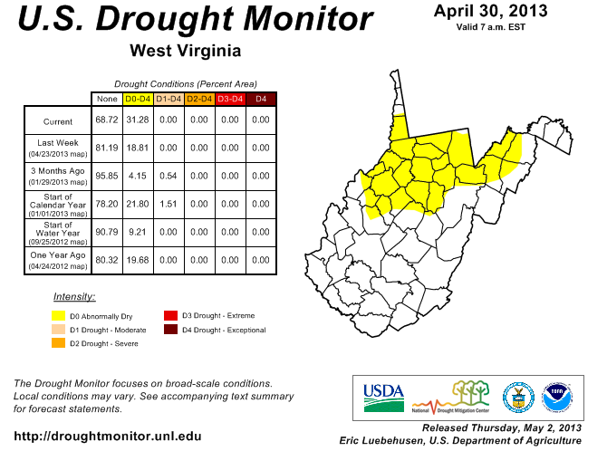

Click to enlarge
This category is not officially considered a drought category but it can be a sign that with continued dry weather, drought conditions may develop. We look to stay dry and sunny right through the weekend. A storm which has been plaguing the middle of the country with rain and snow (yes snow in May) will head our way early next week. Right now, it looks like it will pass to our south, taking the really good soaking rains with it. All week the models has been all over the place with this storm, but more and more of them are starting to come on board with a track across the southeastern U.S. Unfortunately for those hoping for some beneficial rains, it looks like we may have to wait a while for a good soaker. The latest forecast for rainfall over the next week has some impressive amounts falling, just not here unfortunately.

Forecasted rainfall through Friday, May 10th
However, a more northward shift to the current forecast track of this storm would mean more rain for us here in the Mountain State. The track is certainly not set in stone yet, but the fact that more and more of the models are jumping on board with this solution may mean we'll have to wait a little longer for a good soaking rain.
Subscribe to:
Comments (Atom)